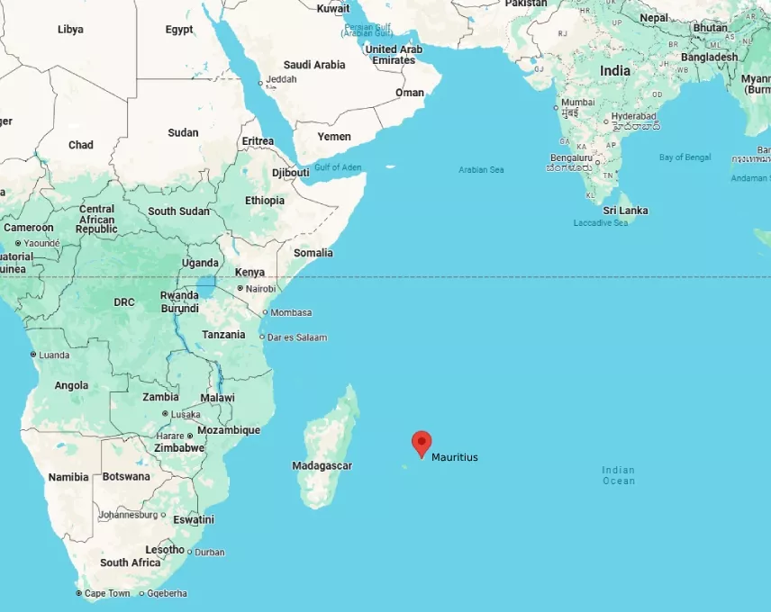
Mauritius occupies a strategic position in the southwestern Indian Ocean at 20.3484 degrees south latitude and 57.5522 degrees east longitude. This placement situates the main island approximately 800 kilometers east of Madagascar and 2,000 kilometers southeast of the African mainland near Mozambique. The country encompasses the primary landmass of Mauritius plus outer territories such as Rodrigues 560 kilometers to the east, the Agalega Islands 1,000 kilometers northward, and the Cargados Carajos Shoals. These features collectively belong to the Mascarene archipelago alongside Reunion Island further southwest.
Surrounding Waters and Oceanographic Features
Deep oceanic trenches and basins exceed 3,000 meters in depth around Mauritius, creating varied underwater topography that supports diverse marine habitats. The South Equatorial Current flows westward through the region, moderating sea surface temperatures and transporting nutrients that sustain coral reef systems encircling the islands. Trade winds from the southeast dominate weather patterns, generating consistent swells ideal for marine biodiversity while influencing sediment distribution along coastal zones.
Proximity to Continental and Island Neighbors
Distances highlight isolation yet connectivity. Mauritius lies 3,500 kilometers southwest of India and over 8,000 kilometers northwest of Australia. The nearest significant landmass remains Madagascar, fostering shared ecological traits despite separation by the Mozambique Channel. Shipping lanes linking Asia to southern Africa pass nearby, underscoring the location’s role in global maritime routes.
– Coordinates confirm placement within the tropics, ensuring year-round warmth. – Exclusive economic zone spans 2.3 million square kilometers, rich in fisheries and potential mineral resources. – Volcanic origins trace to hotspot activity beneath the Indian Ocean plate millions of years ago.
Climatic Influences from Location
Position relative to the equator drives a subtropical climate with wet summers from November to April and drier winters. Cyclones form in the central Indian Ocean and track toward Mauritius due to prevailing winds, shaping infrastructure resilience and agricultural practices like sugarcane cultivation. Coral atolls and lagoons benefit from protected waters created by the island’s central plateau rising to 828 meters at Piton de la Petite Riviere Noire.
Biodiversity and Ecological Significance
Isolation in the Indian Ocean promoted unique species evolution, including endemic birds like the Mauritius kestrel and pink pigeon. Fringing reefs host over 1,000 fish species, while offshore seamounts attract migratory whales and dolphins. Conservation efforts focus on preserving this hotspot amid rising sea levels threatening low-lying coastal areas.
Navigational and Strategic Context
Historical explorers utilized Mauritius as a waypoint between Europe, Africa, and Asia. Modern GPS and satellite data reinforce its coordinates for aviation and maritime navigation. The location supports tourism through accessible flight paths from Europe and Asia, with direct connections emphasizing its mid-ocean vantage.
Economic Geography Tied to Position
Sugar exports and textile industries leverage proximity to African and Asian markets. Emerging sectors like offshore finance and renewable energy from ocean winds capitalize on the stable geographic setting. Regional cooperation with neighbors such as Seychelles and Comoros enhances shared Indian Ocean governance on issues including piracy prevention and sustainable fishing.
Geological Formation Details
Submarine volcanoes built the islands over time, with the main landmass featuring basaltic rock formations and central highlands. Erosion and reef growth created the characteristic white sand beaches and turquoise lagoons visible from satellite imagery of the Indian Ocean. Tectonic stability reduces earthquake risks compared to other Pacific sites.
Travel Accessibility Aspects
Airports on Mauritius and Rodrigues handle international arrivals efficiently due to central positioning. Cruise ships navigate the calm lagoon waters, highlighting the sheltered location. Road networks connect interior villages to coastal resorts, optimized for the island’s compact 2,040 square kilometer area.
Future Environmental Considerations
Rising ocean temperatures from climate patterns affect the surrounding Indian Ocean, prompting coral restoration projects. The location aids monitoring of broader basin changes through local research stations. Sustainable development balances growth with preservation of natural features shaped by centuries of oceanic influence.